I Walk the Line: Protecting affordability near Buchanan Boulevard

murray 2
Pauli Murray mural on the side of an old warehouse on Buchanan Boulevard. The warehouse is now part of the Duke Transportation Center

Story and photos by Lisa Sorg

Note: The public comment period on the Draft Environmental Impact Statement ends Oct. 13. You can comment via www.ourtransitfuture.com .

Near Brightleaf Square, an eerie stretch of West Pettigrew Street parallels an active rail line. Part of the “street” is gravel, and more closely resembles a cowpath. It then crosses Gregson, and curves past the remains of an old, brick house, its lot strewn with trash. Beneath some leaves, I find a woman’s bracelet.buchananbricks

bracelet

Pettigrew Street dead-ends at the Duke University transportation center and impound lot, site of the future Buchanan Boulevard station. For now, though, buses await their scheduled maintenance, garbage trucks nap between routes and discarded parking lot booths transform into terrariums as vines climb inside them. Cars, having violated Duke’s strict parking rules, have been jailed until their owners bail them out.

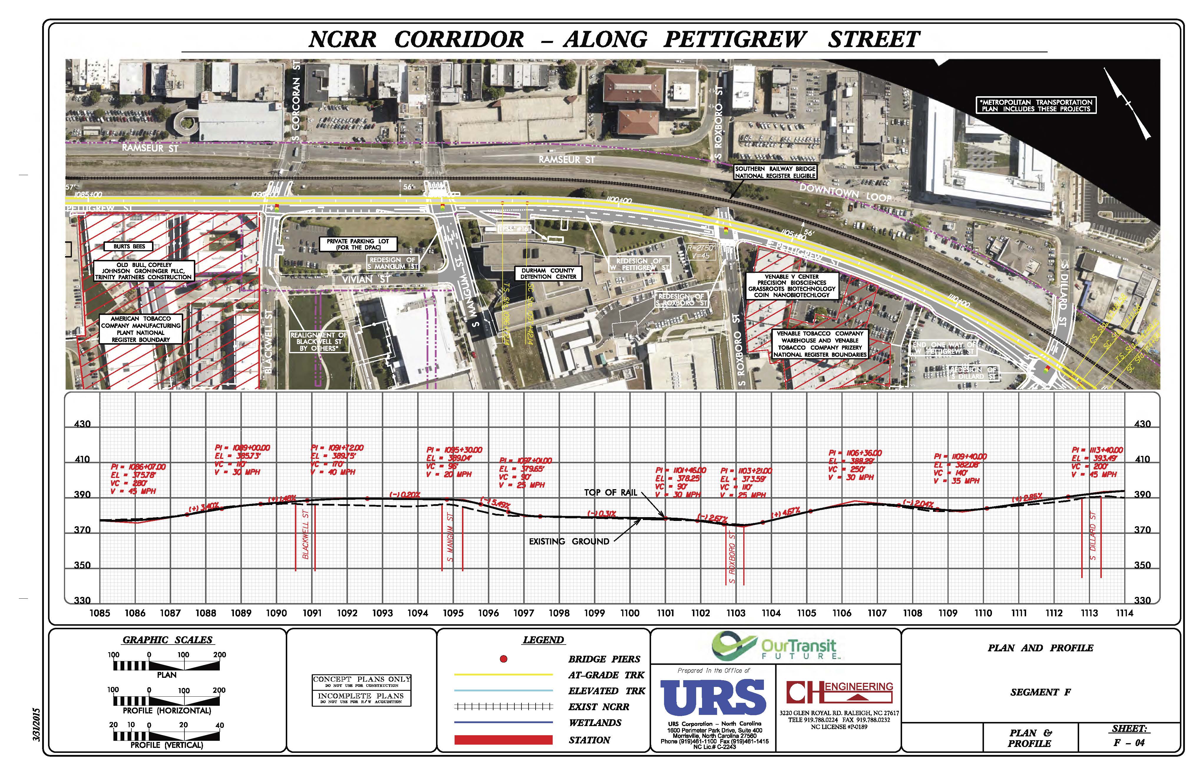
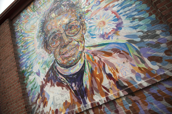
The line originally was to run near Smith Warehouse, but considering the building’s historic significance, the railway was deemed too close. So now, it runs a tad south, through the Maxwell Street parking lot, parallel to the Durham Freeway. As planned, the station would be couched off the street, and take out an old, brick warehouse, emblazoned with a mural of Pauli Murray, the Episcopal saint and civil rights activist.

nvItkk-17-DOLRT_SEGF_SHTS_Page_3

But Durham Area Designers, a volunteer group of urban planners and architects who’ve scrutinized the proposed plan, believe the warehouse can be saved and reused. They submitted public comment, complete with drawings, showing a different proposal that not only preserves the building but also provides more space for transit-oriented development and better connections with the neighborhoods. Screen Shot 2015-10-03 at 11.09.03 AM

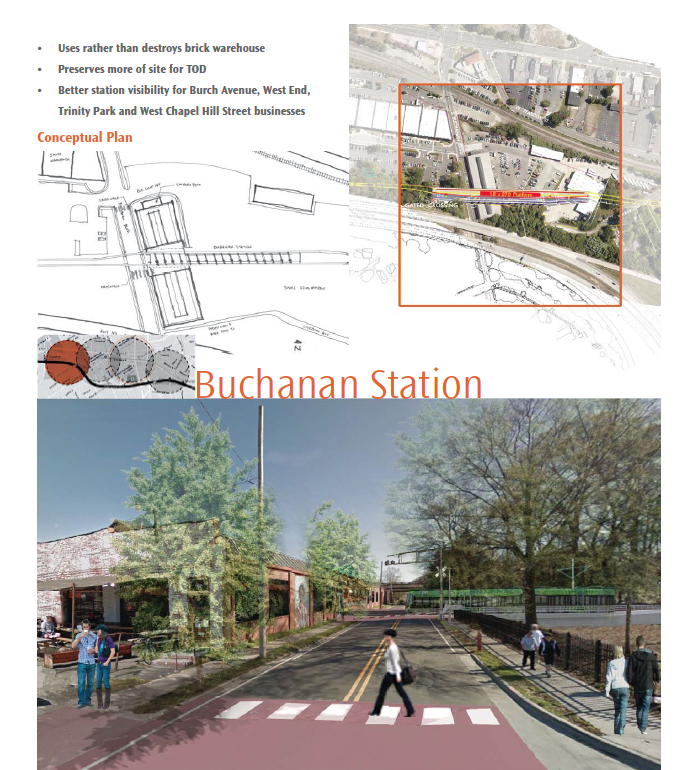
150930_DAD_Durham-Orange Light Rail Transit Project

These neighborhoods—in particular, West End and Burch Avenue, and less so, the already tony Trinity Park, which borders Duke East Campus—are vulnerable to the effects of gentrification: Displacement of low- to moderate-income residents and local businesses along West Chapel Hill Street that have stuck by this neighborhood through thick and thin.

mlk
West Chapel Hill Street

“We’re seeing changes in neighborhoods now. Now is when the planning is happening. Now is when decisions are being made.” —Selina Mack, director of Durham Community Land Trustees, a nonprofit that preserves and creates affordable housing

At Durham CAN meetings, residents have been focused on how to preserve affordable housing around station areas, including the West End and Burch Avenue. Affordability is very much at risk. Mel Norton of the Durham People’s Alliance analyzed 10 years’ of sales data in these neighborhoods, which shows home prices have increased more than 100 percent.

 “There will be a significant increase in rents and property values. It’s happened nationwide. We want the benefits of light rail but not the displacement.” —Patrick Young of the Durham City-County Planning Department

As for renters, a UNC study released this year (see page 36 at the link below for this particular neighborhood), indicated that 78 percent of dwelling units within a half-mile of the station are rentals. Forty-five percent of dwelling units are considered to be affordable; however, very few are subsidized, meaning that increases in property values could compel private landlords to increase rents beyond their tenants’ reach—or flip the houses altogether. The study is here: affordablehousing_possiblesites

dumpster
No touching: Duke University impound lot

This is one of the most diverse neighborhoods in the city, home to the annual Our Lady of Guadalupe parade, Immaculate Conception Catholic Church, the Islamic Center and Joy of Tabernacle storefront church. It sustains the Durham Co-op and the Taiba Middle Eastern Grocery. It’s certainly worth protecting.

Census figures for Burch Avenue neighborhood, from the Durham Neighborhood Compass

Total population 584
Latino 12%
White 51%
Black 31%
Youth under 18 13%
Median household income $24,943
Percentage of residents who are renters 83%
Percentage of renters who spend more than 30 percent of income on house 64%

I Walk the Line: Downtown, the Great Wall and the Great Gap

girl and dog blog
Mr. Big and friend, Pettigrew Street, outside of the Durham County jail

Story and photos by Lisa Sorg

On a recent Saturday afternoon, a woman and her two young daughters stood on the sidewalk along Pettigrew Street, waving in the direction of a small incision in the Durham County jail.

The family had brought their pit bull, Mr. Big, who strained at his leash to sniff and greet me.

“That’s my baby,” the woman said, pointing up at a window.

I could not see her loved one among the anonymous slits in the wall. But she could, which was all that mattered.

I’m one of the few Durhamites who favor the jail—while architecturally hostile as warehouses of human misery tend to be—being located downtown. When we sweep our social issues to the boondocks, we can forget that our problems—and the people caught in them—exist.

However, I’m admittedly in the minority. Many, if not most, Durham residents oppose the siting of the jail, especially considering its proximity to the Durham Performing Arts Center. But the jail was there first, built in 1996 when downtown was desolate. DPAC opened next door in 2008, when the downtown renaissance, while tempered by the recession, began.

The duality is almost poetic: DPAC, with its glass exterior, creates a fantasy; the jail, impenetrable and opaque, presents reality. I’d argue there is room for both.

amtrak_dpac

However, apparently there’s not room for a train station here. GoTriangle has proposed the downtown stop be located at the current bus station, which gives the project points for connectivity. The agency opposes building another station near DPAC, though, not only for financial reasons, it says, but also because the extra stop would slow down the train.

(Fun fact for newcomers: An old freight depot, its side painted with an American flag, used to be along Pettigrew in front of DPAC; it was torn down in 2007 as part of the center’s construction.)

“This location … would create a highly visible gateway, unlike the proposed location at the bus station, which is far from the center and far from walkable.” —Durham Area Designers

Durham Area Designers, a volunteer group of architects and urban planners, disagrees.

(They detailed their thoughts in a letter to GoTriangle: Durham Area Designers DO LRT Downtown Section Comments)

A station at Mangum and Pettigrew streets is necessary to serve DPAC, which broke records last season with nearly 444,000 attendees. Yet nearly two-thirds of DPAC audience comes from outside Durham County. Those from Chapel Hill could ride the train; those car-bound from Wake County could not, because regional connectivity to the east has become a victim of politics.

alston
The downtown light rail stop would be located at the current bus station. The train would travel down one lane of Pettigrew Street, leaving another one-way, eastbound lane for cars and buses.

A DPAC station then, needs to deliver more. DAD says it does. A City Center station at Mangum and Pettigrew, DAD says, would also close the downtown service gap between stops: DPAC, the jail, City Hall, the old county courthouse, and several blocks of the central business district lie beyond the quarter-mile “catchment area”—the distance most people are generally willing to walk to a stop—in this case, the Dillard Street and downtown stations.

“An opportunity would be missed to align the light rail system with the geographic and symbolic heart of downtown Durham,” DAD wrote to GoTriangle. “In short, it would miss the mark.”

Transit researchers have found the optimal distance varies, depending on a city’s walking culture. (We see more people on foot now, but I’d still give downtown Durham’s walking culture a C; further out where sidewalks are scarce, an F minus.) Those living near transit will walk a half-mile; people working near one have a lower threshold, a quarter-mile.

FullSizeRender-3

And consider this DAD idea: GoTriangle should move the downtown station about a block west to the vacant Greyhound station. GoTriangle already owns that property. A station there could connect with the Brightleaf District, DAD says. This site also addresses the bus-train-car-pedestrian axis of evil that already plagues the Pettigrew/West Chapel Hill Street intersection.

smoking_copy
Hanging out by the tracks after the Solidarity March in May. This is at the intersection of Pettigrew and Chapel Hill streets. The Amtrak station is in the background.

This importance of connectivity between the north and south sides of downtown can’t be overstated. Downtown already has linkage issues because of the Downtown Moat, er Fifth Circle of Hell, er Loop. The existing railroad, used by freight and Amtrak, creates a psychological barrier that only the come-hither of the Durham Bulls, DPAC and American Tobacco Campus has managed to overcome.

Earlier this year, DAD persuaded GoTriangle to ditch a plan that would have created the Great Wall of Durham. The light rail line originally was to be elevated, over Pettigrew Street, rather than in the street as it’s proposed now. (Buses and cars have their own travel lane, one-way east.) There was great concern that an overpass would essentially act as a force field between the two parts of downtown. And the Goodmon family didn’t pour bazillions of dollars into the Bulls and American Tobacco Campus—and the city, DPAC—to see a rail line keep people from these money machines.

So GoTriangle got creative. They did it once. They can do it again. And again.nvItkk-17-DOLRT_SEGF_SHTS_Page_5

nvItkk-17-DOLRT_SEGF_SHTS_Page_4